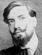

Brazil treated the Portuguese historian kindly. It was not by chance that he was commissioned to curate the remarkable commemorative exhibition of the Quarto Centenário da Fundação de São Paulo [Fourth Centenary of the Foundation of São Paulo], in 1954 (for which he was made an "honorary citizen" of São Paulo, a very rare distinction). In those years of industrious Brazilian exile (1940-1957), Jaime Cortesão developed his major studies, in late maturity, precisely with Brazil as the subject: A "Carta" de Pêro Vaz de Caminha, Cabral e as origens do Brasil (Ensaio de Topografia Histórica [Historical Topographic Essay]), Alexandre de Gusmão e o Tratado de Madrid, Manuscritos da Colecção De Angelis [Manuscripts of the De Angelis Collection], Brasil - libro 1 [Brazil- book 1], De los comienzos a 1799, Pauliceæ Monumenta Historica and Raposo Tavares e a Formação Territorial do Brasil are some of the titles of his remarkable intellectual activity beyond the Atlantic. His work decisively influenced Brazilian historiography, leaving deep marks. It should be noted that he took it upon himself to show the evolution of the map representation of Brazil, while clarifying "the geopolitical bases of its formation".
He sought to resolve or contribute to the resolution of the following questions: "Is Brazil a sufficiently differentiated geographical entity in relation to the other South American States? Does its history also follow its own economic, social, and political development, based on that geographical differentiation? What system of principles and legal titles legitimise and guarantee the geographical basis of the State?" These were highly difficult and complex problems to formulate and resolve and contained, in themselves, an extensive work programme for which the analysis of cartographic documentation served as support and frequently as illustration. Jaime Cortesão assumed that maps expressed first and foremost the political will of the rulers. Although they conveyed a codified view of reality, they reflected above all the purposes of those in charge. Cartography was not objective - even considering the instrumental deficiencies of the time - but disseminated knowledge that was entirely geared towards justifying territorial domination. This could lead to distortions that contaminated what was to be observed.
Jaime Cortesão regarded politics as being so central to cartography that he even stated in his writing that the art of cartography had become stultified by 1640, "as it no longer corresponded to a prevailing political function." He always sought the historical significance of maps. Political significance. In the História do Brasil nos Velhos Mapas [History of Brazil in the Old Maps] in particular, Jaime Cortesão's structural conceptions regarding the formation of Brazil were brought to light: from an imagined "Brazil-Island", defined by the Rio de la Plata and Amazon basins.
